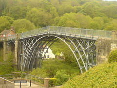
Iron bridge in Ironbridge. And then it started raining, and hasn’t stopped. Currently huddling in a bus shelter at Great Bolas having something to eat and trying to guess if the weather is going to get better or worse.
Category: Uncategorized
Stanton Long
More pretty countryside to cycle through today. There was no room in the inn at Much Wenlock, so i had to come across to Broseley for the night. All in all, 67 miles today, and I got here at 1715 which is my earliest ever arrival. Gps says i was moving for just over 5 hours, which means an average speed of 13.4mph. What a difference a tail wind makes! I spent the last hour of the day sprinting to keep ahead of a massive rain cloud which was blackening the sky behind me.
Techwise, today was all about adapting to changing weather. I just kept the rain covers on my shoes all day. Rain jacket and trousers lived on top of each pannier, held down by the strap so that they were easy to get to. Rain gloves were in the jacket pocket. I also found that i could wedge my map case between the aerobars, which makes it much easier to get to.
So what shall we do tonight? Same thing we do every night – shower, wash clothes, yoga, food, route review and bed.
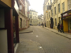
De Greys Tearoom, Ludlow
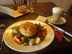
I’m sure i read about this place on someone else’s lejog trip report – probably Andrew McHattie’s.
I stumbled in here, panniers swinging, before i made the connection. I’d describe it as the Jenners of the tea room world. I think i walked past Miss Marple on the way in. Not exactly cyclist central, but i’ve got used to brazenly stomping into delicate tearooms with full cycling gear. They served a tasty steak pie but lousy latte – but what was i thinking walking into a tea house and asking for coffee?!
I managed 40 miles before lunch at 1pm, aided by a useful tail wind. Wait, what’s that? It’s like a wind . . that helps you rather than hinders you. A cyclist power-up if you like!
Weather has been showers on and off. I’ve stopped four times to shelter under trees to avoid the worst of the rain, but the wind blows it over quickly (the rain, Anthony, not the tree!). I was very focused on getting the miles done this morning, lots of heads down pedalling and munching of snacks whilst on the move. The biggest hassle was switching clothes a million times – jacket on, jacket off, rain trousers on, then off again. Still, i have my gear stowage nicely optimised now! Another 25 or so miles left to Ironbridge, though the forecast for the afternoon was poorer.
Withington
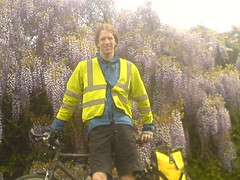
I was looking in my phone camera to see if the had am exposure control (no) but i did find that it has a timer mode! So more self portraits from now on, and fewer photos of road signs. However, i did suffer my first nettle sting of the trip whilst setting up the shot!
Travels with my Spork

Never leave home without your spork. So far i’ve used mine to fix a puncture, eat food, align dilithium crystals and create controlled nuclear fusion.
Ross on Wye
Ross on Wye turned out to be a lovely place to spend an afternoon. I got a new water bottle finally and had a very pleasant lunch, coffee and cake!
Tintern to St Briavels.
A note for future lejog people, once you turn off the main road after Tintern, the wee roads are somewhat confusing. i missed the first turnoff because it looked like someone’s driveway. Then i got very confused as to where i was and had to plump for carrying on up and down hills in the hope i’d hit the main b road. which, i eventually did.
Turns out, Google Maps satellite view is great for revisiting and analysing your mistakes!
The best laid plans
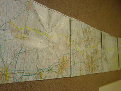
Due north for the next 5 map pages!
I’ve reworked my plans a bit. Partly to get to places on days when my family can make it along for meetups, but mostly because the longer days i’d planned for the next few stages just don’t look sane given my typical days so far. And of course, who knows what the weather will do! So, here’s the revised plan.
Sat, Ross on Wye to Much Wenlock.
Sun, to Middlewich
Mon, to Whalley
Tue, to Kendal
Wed, to Gretna
I dug around on the gps last night and found that its route point memory is full with 10 routes containing 50 points. I’m sure the internet said it stored 20 routes and 50 points. Regardless, shame on me for not verifying. Still, i’m very glad i bought a good waterproof map case, because it means i can bungee it to the bike rack and check it fairly easily. Not as good as a bar bag, but i didn’t want one of them – another bag to lug, no space on bars anyway. It’s been rained on lots, and maps are still dry. Still miss the gps a lot, though it’s still been a big help even just in track mode.
Another day, another county
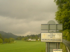
Made it to the bnb in Ross on Wye. Of course, the moment i stopped, the rain stopped too, grr. Psychologically, i’m a bit frustrated about the weather-based change of plan. I feel fine, and could do many more miles today but after yesterdays soaking, and similar downpours today near Tintern, i need to dry out. On one hand, i tell myself that it’ll be good to have a half days rest. But on the other hand, i don’t really need or want a rest stop. I’ve cycled nearly 300 miles in the last 4.5 days, but energywise i’ve been in a pretty steady state since day one. Still, i’m glad i left Chepstow and did at least some distance today – only 30 miles but that’s 30 more miles done regardless.
Tintern
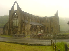
Tintern Abbey, in the wet. At Coleford now. Booked bnb in ross on wye so short day today. 13m to go.