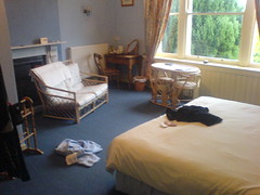
Just wanted to say thanks for all the comment, emails, texts and sponsorship over the last few days. It’s great to hear from people, especially when i’m in the middle of nowhere at the time! ?Mostly for my own recollection, here’s what my days look like: ?0745 Get up, watch weather forecast.?0800 Breakfast. Cereal, full english, lots of toast and tea.?0830 Review route, get changed into cycling gear, put on suncream and repack panniers.?0900 Start pedalling. Repeat until hungry.?1130 Stop for tea and pancake stack.?1200 Lots more pedalling, some pushing! ?1330 Stop for soup, cake and tea.?1415 Pedal pedal. Take rain gear off and on several times.?1715 Brief mega snack from my panniers. Avoids the late afternoon crunch which i noticed on day 2.?1800-1900 Arrive at bnb, have shower.?1930 eat dinner. This has been tesco’s pasta on day 1, fish and chips on day 2 and a 3 course sit down meal tonight. ?2030 wash cycling gear in sink, dry using the magic travellers method involving rolling in a towel.?2100 stretches and a bit of yoga. ?2130 pre bed snack, some flapjacks or nuts and hot chocolate. Plus lots of texting and internetting. Mobile internet is so cool. Opera mini is particularly impressive, but the phone in general is a really capable device. After typing all these blog posts on my phone keypad, i think i can probably text as fast as am average 14 year old now! ?2230 and so to bed. On day 1 i kept dreaming about pedalling and turning corners, but hopefully my brain is over that now. 🙂 ?Oh, photo is of my rather spacious room in the bnb which turned out to be a mansion!
Month: May 2009
Day 3 retro
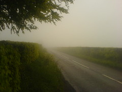
Hehe, i just did Cornwall and Devon, woot! And furthermore tomorrow has all of the flat. Well, possibly all of the rain too, but you can’t have it all it seems.?Anyhow, the photo is of the Brendon Hills in Exmoor during today’s ‘can’t see a thing’ phase. Glad to have made it down to sea level after that somewhat exciting excursion.?The day started with me retracing my step back from the farm into torrington. Somehow the road didn’t seem as long as it did yesterday and the hills weren’t quite as steep, hmm. Then i followed the ctc route up to Atherton, featuring today 41mph highlight. During that, and subsequent bumpier descents i began to fully appreciate the art of good bicycle design – something which worked fine at low speed could become a nightmare at high speeds.?I stopped in a tea shop in south molton for an extra breakfast. I’m a bit shocked by how much i’ve been physically able to eat today. Next was the dreech and lonely grind up 400m into Exmoor. Once up, things got faster for a while, and i got lots of aero bar time despite the rain cloud i was in. More descents and climbs were the pattern for the day. I even outran some cars on the descent into Enmore. :)?The gps has saved my bacon lots today. I’d be so screwed without it. On the odd occasion i go the wrong way anyway but the gps quickly makes it apparent that i’m headed in the wrong way. Them satellites sure do rock.
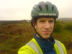
Head in the clouds.
Reaching 400m for the second time today. However, the cloud base was at about 300m which meant visibility was down to maybe 50m for a while. Fortunately it was quiet and you can hear cars coming way in advance so i could duck off the road if i was coming near a bend.?I’m currently standing at the bottom of the last steep hill of day 3. Woo, no more hills after this for a while. I think it’d be a stretch to say that i’m going to appreciate or enjoy the hill in any way however! I’m beginning to wonder how many of the 14 day lejog’ers i found on the internet were doing it solo and unsupported. Still, i’m still going and basically don’t feel bad at all. I could do with having more patience i think! That’s about all.
Exmoor
Exmoor, aka the middle of nowhere. Given that the map was green in this area, i thought the whole thing was forest. But, no, it is plain old full of nothing moorland. And, having made it up the 400m ascent after north molton I was rewarded by . . . being in a cloud. On with full waterproofs for the first time this trip. But today has seen fewer short sharp hills and more rolling countryside. The one short sharp climb was made more fun by having a huge two stage sheep lorry attempt to get down into the village. In the end, the lorry driver had to get out and manouver a car belonging to a clueless local back down the hill in reverse. ?H’ve stopped for lunch in a lovely tea room in Winsford. However i’ve come to realise that any village which has a stream running through it is usually followed by a big climb. Time to find out!
Last night

Last nights sunset was super pretty. I’m currently paused in south molton having a second breakfast! First one was full english fry up. Now i’m having a stack of 4 pancakes and some tea. In 10 miles or so I’ll be out of dorset!
Speed

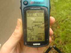
Woo, new top speed attained. 41mph. Now i’m going to have to walk up the other side of the valley tho!
Breakfast

The view from the breakfast table at Furze Farm in torrington. Forecast is for 12mph winds coming from the south. Today is all east across Exmoor towards the flat flat promised land beyond. Showers today and some proper rain tomorrow, but i know my rain gear is pretty good. Anyhow, time to finish shovelling food and repack before hitting the road.
A good sign
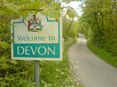
Phew, that’s Cornwall done! And, to be honest, i’m glad. Them cornish hills lived up to their reputation. Tired legs and bags meant i had to push up a fair few hills today. But what kind of crazy person at the ctc thought it was a good idea to route over 3 30% gradients? Grumble. One of those descents had just been resurfaced too, which lead to some exciting glentress moments. ?Anyhow, some highlights. There was a brilliant fast long downhill into Tintagel which was a lot of fun. Uhm, and the headwind had dropped from 35mph down to 16mph. Small mercies. Hmm, i’m struggling for good news here. The approach to Torrington include a walk up the steepest residential street i’ve ever seen – mill st is as steep as cockburn st in edinburgh but about 4 times the length. Oh, navigation is good. Loving the gps. I did ad lib a couple of times today, and regretted it every time. And i’m enjoying the ipod when i’m on quiet country roads, although i got some surreal tune picks going up big hills, particularly Prince Charming. ?The other thing which has been notable is the kindness of strangers, even including the countless car drivers who have patiently waited behind me until i reached a point where i could pull in and let them by. The lady who runs tonights bnb have me a lift back into town so i could get food. The builder who i asked directions from were great. Yay for humanity! (I wasn’t saying that on friday night when my motorbike got pushed over for the second time in 2 months).?Anyhow, i need to check in with home to see where i’m staying tomorrow and get a preview of the hills. I know that day 4 is super flat, with the exception of cheddar gorge. But i think day 3 is every bit as hilly as today was. Still, i made it to here and i don’t feel too bad really. No injuries or awful aches yet. Hopefully the wind will turn tomorrow and I’ll get a break. Just keep swimming, just keep swimming . . .
Irony

Funny sign just before Tintagel. As it turns out, not such a funny morning. Followed the ctc route along the coast. Bad plan. 30 percent slopes do not make for good cycling, especially when they’ve just resurfaced the road. Lots of walking and pushing, boo. It’s a rubbish route really. Pretty, but not for cycling. Made it to Bude for a late lunch, and i’m really hoping the next 30 miles inland are all downhill. Kinda wish i’d printed out the elevation profiles so i’d know what is coming.
Cracking Haven

Massive climb out of Boscastle, then crazy descent to Cracking Haven. Have confirmed that gravity is a conservative field.